Monthly Archives: July 2013

Kettle River Q&A – “Crap” in the river

In a recent column about sediment I noted that fecal coliform bacteria had been rising in the Kettle River at Midway. Some readers asked me to spell out what that means.

Fecal coliform bacteria are a large group of microscopic organisms which live in the intestines of warm-blooded animals, including humans, cattle, and deer. They also live in animals’ feces, or “crap”, and continue living for a time in soil, streams, lakes, or groundwater.

When water meets crap, its load of bacteria, viruses and parasites can be carried into streams and lakes or even into groundwater. Bacteria can thrive in the right conditions or be killed off by sunlight.

These bacteria are not necessarily agents of disease, but are measured because they indicate the possible presence of other disease-carrying organisms. The deaths and illnesses in Walkerton, Ontario, were a tragic reminder of why we need to monitor and manage bacteria in water sources, in particular for deadly strains of E. coli.

Increasing fecal coliform bacteria could be due to livestock, failing septic systems, or poorly performing wastewater treatment plants. Other important sources include wildlife, pets, and stormwater runoff in urban areas.

Scientists measure fecal coliform bacteria by counting the number of bacterial colonies (colony forming units, or CFUs) per 100 ml of water. For water to be safe to drink without treatment there should be no colonies present, according to the BC Water Quality Guidelines.

Low levels (less than 10 CFU/100 ml) require disinfection, and greater numbers require higher levels of treatment. Other standards exist for recreation, shellfish harvesting, irrigation, cattle watering, and food processing.

We, as individuals and communities, can help prevent and manage “crap” in our waters by:

  • Picking up after pets
  • Watering and feeding cattle away from rivers, streams and wells
  • Practicing good manure management (composting, field application) and preventing buildup in wet areas
  • Encouraging native trees and shrubs to grow around the edges of water bodies because they act as filters
  • Placing and maintaining septic systems properly and according to regulations
  • Placing and maintaining wells far from septic systems, flood waters, and agricultural runoff
  • Testing water supplies regularly
  • Maintaining and updating sanitary and storm sewers in urban areas

The Stakeholder Advisory Group will be looking at these and other strategies for protecting water quality and managing risks to drinking water this fall – stay tuned to our website at https://kettleriver.ca.

Further reading:

— Graham Watt is the coordinator of the Kettle River Watershed Management Plan for the RDKB, and is working with a Stakeholder Advisory Group from across the region to develop the plan. Email [email protected]
Thinking like a watershed – building natural resilience to climate change

The  recent flooding disaster on the east slopes of the Rocky Mountains has highlighted the need to do more to prepare for and avoid the impacts of similar floods in the future. Leading water experts at the Canadian Water Summit on June 27 were asked about what all levels of government should consider to mitigate flood impacts. Here’s what they had to say:

  1. Anticipate more extreme weather events and plan for them.
  2. Improve our operational predictive capacity through better modeling and data management.
  3. Invest in infrastructure such as on and off stream storage, diversions, and natural storage such as wetlands.
  4. Consider flood risks in municipal planning, including building in flood plains, and better engineering of electrical, mechanical and back-up systems.
  5. Manage our water resources collaboratively, following the example of the Bow River Consortium, and ensure proper funding for the watershed planning and advisory councils across the Province.

The third strategy mentions infrastructure, both engineered and green, to hold back water. But the value of ‘green infrastructure’ goes well beyond water storage and includes sediment reduction, water quality improvements, and many other benefits. Indeed, as part of a range of strategies to store water, protect bank stability, and reduce flood damage, protecting and restoring our riparian, wetland and floodplain ecosystems will help make our settlements more resilient to climate-heightened floods.

In a recent article in The Common Sense Canadian, David Suzuki called for valuing ‘natural capital’ as part of the flood management equation:

While calls are mounting for the need to rebuild and strengthen infrastructure such as dikes, storm-water management systems and stream-channel diversion projects, we’ve overlooked one of our best climate change–fighting tools: nature. By protecting nature, we protect ourselves, our communities and our families.


The business case for maintaining and restoring nature’s ecosystems is stronger than ever. Wetlands, forests, flood plains and other natural systems absorb and store water and reduce the risk of floods and storms, usually more efficiently and cost-effectively than built infrastructure. Wetlands help control floods by storing large amounts of water during heavy rains – something paved city surfaces just don’t do.

How would this approach be applied in the Kettle River Watershed?

“Thinking like a watershed” would mean considering how patterns of forest harvest, road management and rural development contribute to sedimentation, flood response and low flows during drought. It would mean considering potential changes to river channels and flood levels over decades when planning future land use in the floodplain. And it would mean, collectively, stepping back from the water and helping riparian and wetland ecosystems to do their work of dissipating flood energy and filtering sediment.

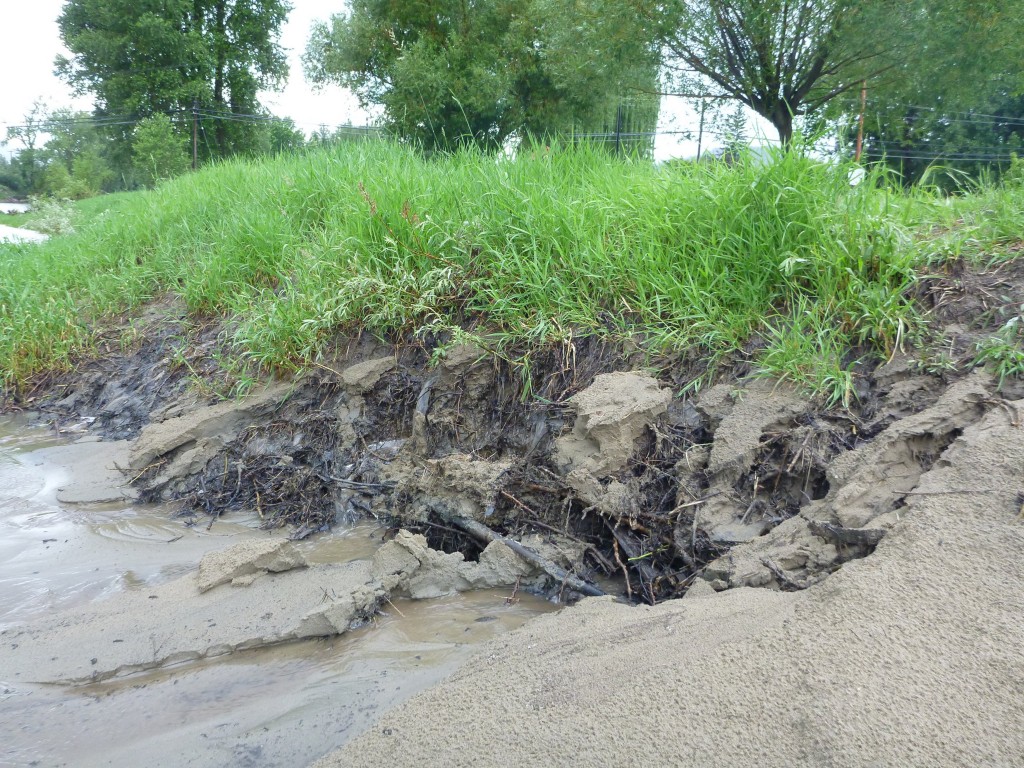
Grasses do little to slow erosion on the banks of the Kettle River in Grand Forks.
Water and sediment pour into the Kettle River off a gravel parking lot and grassy area in Grand Forks during the rainstorm on July 8. Grasses do little to slow the erosion and hold the bank together compared to woody shrubs and trees – remnants of their roots can be seen at the base of the bank.

But we won’t be able to make these changes overnight. We have our roads, properties, businesses, farms and industries in the path of future floods. Appropriately, we have public safety and property protection in mind when responding to flood emergencies.

Furthermore, current economic models and land valuation don’t account for the full worth of forests, streamside shrubs or urban wetlands. Landowners, developers and banks don’t have the knowledge, legal tools, or policy support to account for natural capital on properties.

So where do we start? By talking about resilience in our communities, by planning ahead for the kind of changes we anticipate with climate change, and by building the relationships we need to adapt successfully.

On the evening of September 26 in Christina Lake, join the Kettle River Watershed Management Plan Stakeholder Advisory Group at a special forum, “Flood, fire & famine: adapting to global changes with climate resilience in the Boundary.”  Advisory Group Chairperson & RDKB Area ‘C’ Director Grace McGregor and a panel of experts on food systems, ecosystems and watersheds will lead participants through provocative dialogue about how we can develop regional solutions for climate adaptation.

Comment on the future timber supply management for the Boundary

VICTORIA – Comments are being accepted until Sept. 5, 2013, on a public discussion paper released today as part of a comprehensive timber supply review for the Boundary Timber Supply Area.

Public feedback on the discussion paper will be considered by the chief forester before setting a new allowable annual cut. The current allowable annual cut is 700,000 cubic metres. The discussion paper describes the geography, natural resources, forest management and land use plans of the Boundary Timber Supply Area. It also provides the results of the timber supply analysis, including a base case harvest forecast.

The Boundary Timber Supply Area covers about 659,000 hectares, but only slightly over 272,000 hectares is available for timber harvesting. Communities in the timber supply area include Grand Forks, Greenwood, Midway, Christina Lake, Rock Creek, Bridesville and Beaverdell.

The chief forester’s allowable annual cut determination is an independent professional judgment based on information such as technical forestry reports and input from First Nations and the public.

Under the Forest Act, the chief forester must determine the maximum amount of wood that can be harvested in each of the province’s 38 timber supply areas and 34 tree farm licences at least once every 10 years. However, a new allowable annual cut may be determined earlier in response to abnormal situations, or postponed for up to five years if an allowable annual cut level is not expected to change significantly.

To view or download a copy of the discussion paper, visit the Ministry of Forests, Lands and Natural Resource Operations forest analysis and inventory branch website at: http://www.for.gov.bc.ca/hts/tsa/tsa02/index.htm


Kettle River Q&A – What is sediment and what does it mean for the Kettle River?

Raging, brown water carrying homes, cars, and boulders downstream: these images from the flooding last week in Alberta and southeastern BC have haunted me the last few days.

That brown stuff in those waters, sediment, is worth contemplating in the Kettle River and its tributaries. I’m picking on it today because it has been increasing in recent years.

Sediment is a good indicator of watershed health as it responds to changes in land management and disturbance. It is also associated with other water quality issues, and strategies to reduce erosion would help improve many other aspects of surface water quality.

Sediment is a naturally-occurring material broken down by erosion from ice, wind, or water. It ranges in particle size from less than a micrometre (0.000039 inches) for clay mud to greater than 256 mm (10 inches) for boulders.

Fine sediment (clay, silt, and fine sand) can be carried easily in stream currents as suspended sediment. It can be measured by filtering water or estimated by examining the scatter of light, or cloudiness, in water. This is called turbidity.

Increases in suspended sediment can degrade fish spawning areas and directly harm fish, mussels, and aquatic invertebrates. Spawning gravels can become ‘clogged’ with silt, reducing oxygen and clean water flow for developing eggs. Fine sediment can also irritate fish gills and cause mussels to stop feeding.

Sediment often carries other pollutants (nutrients, heavy metals, and bacteria), and makes it harder to treat drinking water from surface sources.

There was a small but statistically significant increase in fine sediment (turbidity) between 1990 and 2008 at the Canada-BC water quality monitoring station at Midway. Between 2000 and 2008, counts of fecal coliform bacteria also increased significantly and have been above water quality guidelines for drinking water.

Larger sand, gravel, cobble and boulders that are moved during higher flows are called ‘bedload’. Bedload moves slowly through river systems, often taking decades to move from landslides through river valleys.

Steep, eroding banks provide coarse and fine sediment to the Kettle River in the Nursery area, downstream of Grand Forks.
Steep, eroding banks provide coarse and fine sediment to the Kettle River downstream of Grand Forks.

Increased bedload can raise the elevation of the river bed (aggradation) and fill in deep pools needed by fish. It also leads to widening and braiding of the river channel, causing more loss of property and roads along the river.

We don’t have measurements of coarse sediments in our rivers, but recent observations of erosion, braiding and widening channels on the Granby River suggest increased bedload and aggradation. It will require further studies to see how the Granby has changed and how landscape changes have contributed.

Future columns will look at natural and human-caused sources of sediment in the watershed and potential solutions for reducing erosion that will be considered for the watershed management plan.

— Graham Watt is the coordinator of the Kettle River Watershed Management Plan for the RDKB, and is working with a Stakeholder Advisory Group from across the region to develop the plan. Email [email protected]

Further reading: