Spring has sprung, and water levels are starting to rise as the snow level drops. Read on to see how our current water levels compare to previous years. Spoiler Alert: we are experiencing water levels higher than normal for this time of year, with some reaching levels typically seen during a normal spring melt (freshet). Snow levels are decreasing quickly at some stations, bringing the high snow level station to a more average level. The Provincial snow report for April2025 describes the snow levels in the Boundary Region as normal for this time of year.
With local temperature remaining warm, reaching highs between 10-15°C over the next week and minimal precipitation expected, it’s a good time to access local conditions.
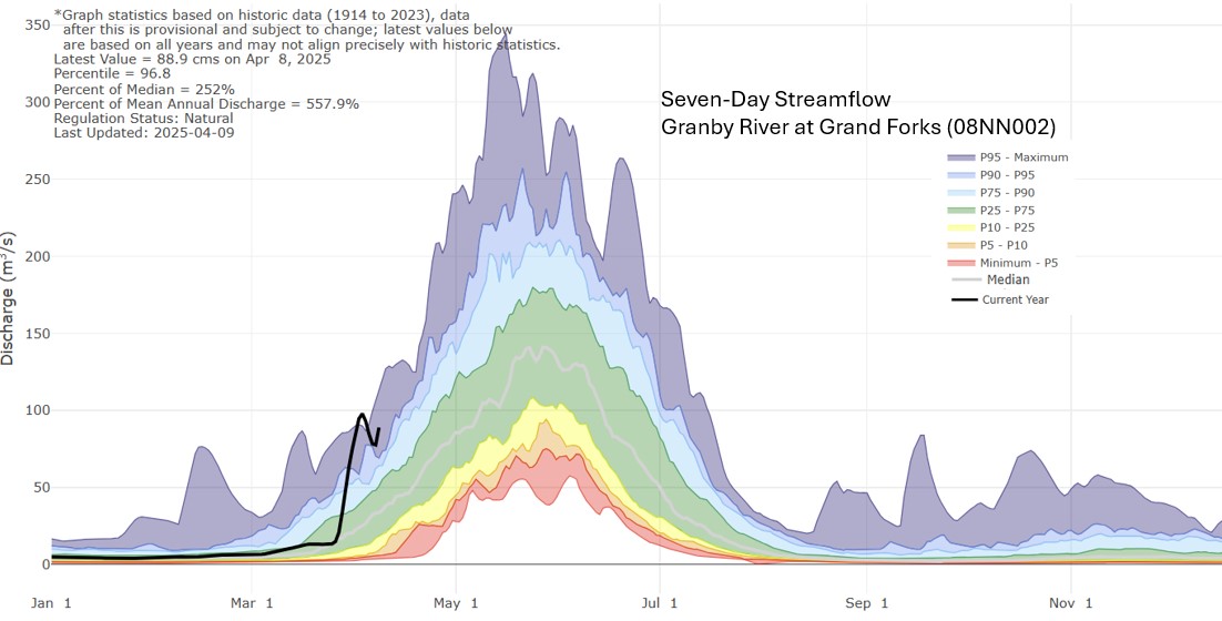
Many rivers and streams in the Boundary region experienced a sudden rise due to recent warm weather and rain. Below is the hydrograph for the Granby and Kettle River (south of Midway).

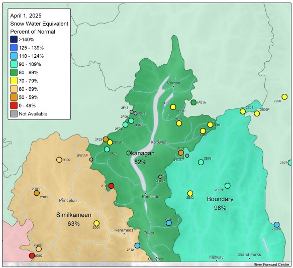
Province produces a monthly snow report (April 2025), indicating snow levels in the Boundary Region are overall normal for this time of year, an assessment based on 4 monitoring stations (Figure 3 and 5). As we know, snow levels vary across the region and with elevations changes. South of Grand Forks at Sentinel Butte, it’s snow levels are dropping to more typical levels; along with the Grano monitoring station, located in the upper Kettle River watershed, also within a normal range (Figure 4). With the lower elevations stations (Carmi and Monashee Pass) are slightly lower than normal for this time of year.


Environment Canada forecasts a warmer than normal spring for the Boundary region, with the potential for drier conditions (Figure 7). Temperature Probabilistic Forecasts


As we transition into the spring melt period (freshet), here are some useful resources to monitor:
- RDKB Emergency Operations: The Boundary Region Dashboard is now being updated, offering an overview of freshet conditions across the region. emergency.rdkb.com/
- River Forecast Centre (CLEVER) provides water level forecasts for 10 rivers throughout the Boundary Region.