More and more science is finding the importance of protecting headwater streams for aquatic ecosystem health, biodiversity, and downstream water quality and drinking water protection. In this research note, USDA Forest Service ecologists examined the effect of variable-width buffers greater than 50 ft (15.24 m) on non-fish-bearing streams. This has implications for improving stream protection in our active forestry areas, where there is very little protection for small streams and wetlands.
From: http://www.treesearch.fs.fed.us/pubs/49761:
Since the Northwest Forest Plan implemented riparian buffers along non-fish bearing streams in 1994, there have been questions about how wide those buffers need to be to protect aquatic and riparian resources from upland forest management activities. The Density Management and Riparian Buffer Study of western Oregon, also initiated in 1994, examines the effects of thinning and different buffer widths on aquatic and riparian vertebrates and habitats, tree growth, and vegetation along headwater streams.
Dede Olson, a research ecologist with the Pacific Northwest Research Station, leads the riparian component of the study. Olson and her colleagues found that aquatic and riparian species and habitat were retained with no-entry, 50-foot minimum variable-width buffers.
Their research has characterized both aquatic and terrestrial amphibian assemblages that rely on headwater streams and near-stream riparian forest habitats. For example, they documented that terrestrial salamanders have heightened movements within 50 feet of headwater streams. By extending such buffers along headwater streams over ridgelines, landscape connectivity could be provided, enabling gene flow among populations of terrestrial salamanders.
Scientists found that thinning upslope accelerated growth of trees within the buffer within 50 feet from the thinned edge. Larger trees ultimately lead to larger pieces of down wood, which form critical habitat both on land and in streams
Authored by POLIS researchers Oliver M. Brandes, Savannah Carr-Wilson, Deborah Curran, and Rosie Simms, the report outlines what is needed to put the “sustainable” in the Water Sustainability Act.
With the new Water Sustainability Act replacing the 106-year-old Water Act in 2014, British Columbia has a once-in-a-lifetime opportunity to modernize its freshwater legislation and usher in a new era of water stewardship. The Water Sustainability Act has many promising features that can better protect the province’s fresh water. Yet full implementation of the new Act hinges on passing critical supporting regulations that will provide the necessary details to make the Act fully functional.
Awash with Opportunity: Ensuring the Sustainability of British Columbia’s New Water Law provides a timely analysis of the Water Sustainability Act and its core regulations required for it to reach its full potential as a comprehensive and modern water law. It offers clear recommendations based on leading international practices in five key areas:
Groundwater,
Environmental flows,
Monitoring and reporting,
Water objectives, and
Planning and governance
British Columbia’s fresh water is under pressure from an array of threats, including climate change, population growth, and escalating and competing demands for water. Conflict and concern mounts as watersheds across the province show signs of stress and pressure from unprecedented droughts. Water quality degradation and skirmishes over water use increase the urgency to act.
A comprehensive water law regime that includes a fully implemented Water Sustainability Act and a full suite of supporting regulations is a necessary condition to ensure that future water challenges do not become debilitating water crises.
The report specifically offers the Provincial government the necessary advice and insights needed to move beyond crisis response toward a fresh partnership approach with shared roles and responsibilities to protect B.C.’s water resources—now and into the future.
For more information, see the November 16th front-page article in The Province, which discusses the Government’s recently announced water rates and the findings of the new report; Rosie Simm’s discussion of the new report with Victoria’s CFAX 1070 on November 21st, or the forthcoming article, written by the report’s co-authors, in the Winter 2015 issue of BCWWA’s Watermark magazine.
The Shoreline Master Program (SMP) is a combination of planning and regulatory documents. SMP documents carry out the policies of the Shoreline Management Act (SMA) (RCW 90.58) on local shorelines. Local governments are required to prepare SMPs based on state laws and rules. SMPs are prepared to implement the SMA to prevent, “harm caused by uncoordinated and piecemeal development of the State’s shoreline.” Local SMPs are tailored to local geographic and environmental conditions, as well as to existing and future planned development patterns within the shoreline.
The SMP update process balances and integrates objectives and interests of local citizens. Key principles of the SMP include striking a balance among environmental protection, public access and water-oriented uses, and achieving “No net loss” of ecological functions.
What’s New?
The Ferry County Planning Commission and City of Republic are holding a public hearing to review the proposal to adoption the new SMP.
Public Hearing
Wednesday, December 9, 2015 at 6:00 p.m.
147 N Clark, Suite 7,
Republic, WA
(Top level of building across Clark street from the Post Office)
In the last column I reviewed a few of the main activities and initiatives of 2015 for the Kettle River Watershed Management Plan. Today I want to look ahead to 2016, sharing a few of the priorities in the Plan that our Steering Committee and Advisory Group are committed to achieving.
On November 19 we held a second meeting with a large group representing water suppliers from across the Boundary. There were farmers, municipal councilors, small water utility operators and technical staff, there to talk about how we can better respond to drought.
Two main points emerged. First, the group identified that more information sharing and education was needed for water users and ratepayers in how (and why) to reduce water use in different settings. That could include everything from bulletins and columns to hands-on demonstration and door-to-door contact to support compliance with water regulations. This relates to several actions in Strategy 1 in the Plan.
Second, the group recommended developing a common approach and terminology in a water conservation and drought response strategy (Action 2.3.1 and 2.4.1). The BC Drought Response Plan clearly articulates a role for local partnerships in responding to drought, providing a good starting point for our discussions. Though as some group members pointed out, our strategy needs to be proactive, not reactive, by instilling widespread water conservation practices that help reduce the impacts of drought before we even get to water restrictions.
We will be discussing these points with water suppliers over the coming months in order to develop a sound and well-supported strategy that could be adopted as policy across the region.
Another major initiative for 2016 is building an online map-based interface so the public and decision-makers can learn more about their water supplies, discover reports and monitoring information, and connect the dots between different issues (Action 1.2.1). Relevant information is currently housed in dozens of different websites and databases, making it difficult to put together a current and coherent picture of issues such as drought, land use impacts or ecosystem stresses.
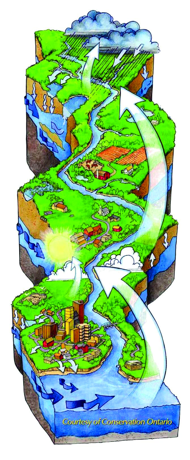
The water cycle and the watershed. Courtesy Conservation Ontario.
Throughout the planning process, many people have shared their concerns about protecting the headwaters – our ‘water towers’ in the mountains and plateaus – from the impacts of different land uses and activities. While some point the finger at one group or another, the problems are really cumulative and interconnected, so we need to look deeply at the issues (as in the Granby Wilderness Society’s Riparian Threat Assessment) then work together on meaningful solutions (Direction 3.1 and 3.2).
To that end, we are planning to work with the Okanagan Nation Alliance Natural Resource Committee to co-host a community forum this winter on protecting the headwaters (Action 1.1.5). We are really excited about learning more about our common interests in the headwaters and about First Nations knowledge and perspectives about land and water. Stay tuned for more details.
We will be continuing to work with the Boundary Habitat Stewards and other partners to restore habitat around streams, lakes and wetlands, and connecting with planning initiatives by local governments, forestry and agriculture to improve watershed health and function.
Of course, there are other priority actions that various stakeholders wish to support or lead as we move forward – I look forward to hearing from you about your priorities and commitments. As the Plan indicated, many different organizations share responsibility among their various jurisdictions for protecting and managing water, and we need to work together to ensure policies and practices are connected, consistently and effectively, by the one common thread of healthy, functioning waterways and ecosystems.
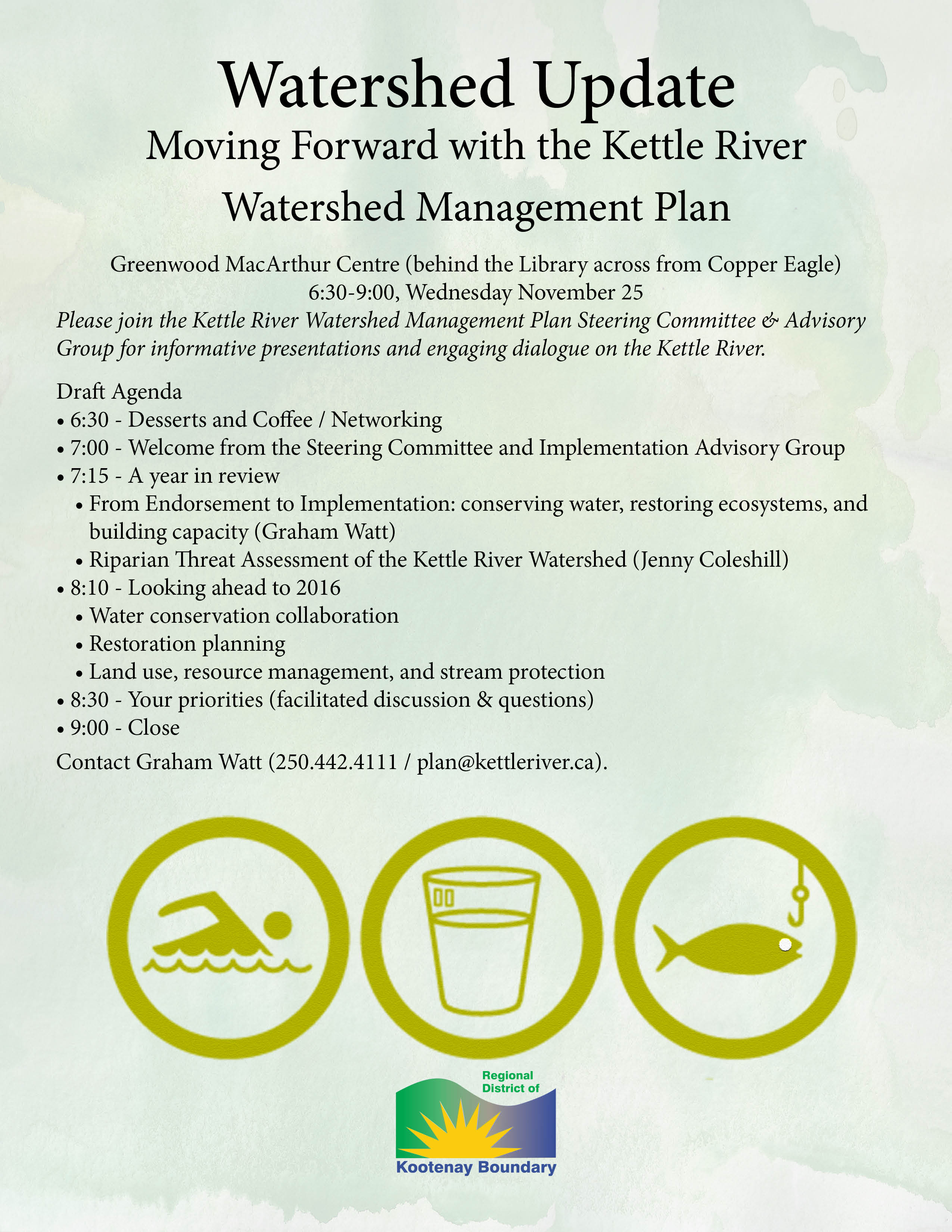
To learn more, come to Greenwood’s MacArthur Centre behind the Library on Wednesday evening, 6:30-9:00. Desserts, coffee, and good conversation!
Please join the RDKB Kettle River Watershed Management Plan Steering Committee and Advisory Group for informative presentations and dialogue – and dessert! Greenwood MacArthur Centre November 25, 6:30-9:00 p.m. Contact [email protected] for details.
 Dede Olson, a research ecologist with the Pacific Northwest Research Station, leads the riparian component of the study. Olson and her colleagues found that aquatic and riparian species and habitat were retained with no-entry, 50-foot minimum variable-width buffers.