Category Archives: Boundary Region Drought Updates

Conditions – Jul26,2024

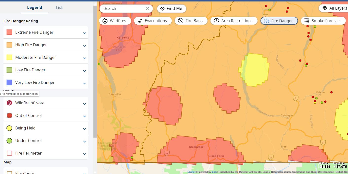
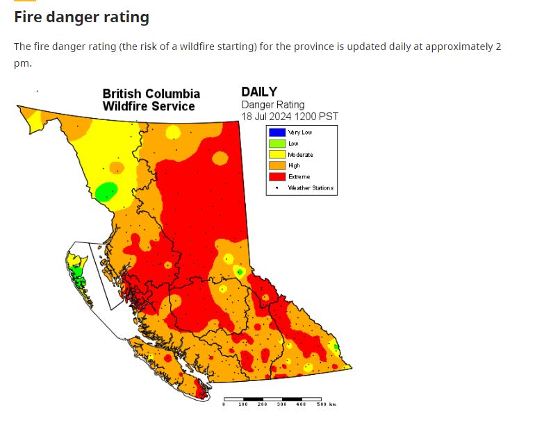
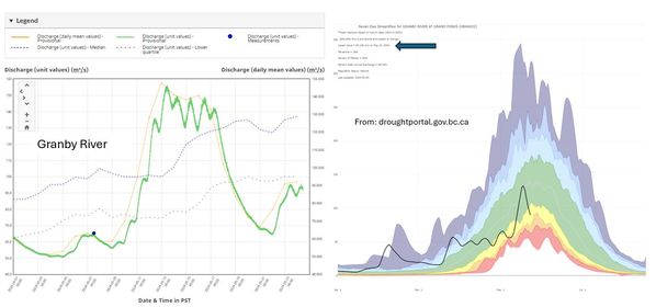
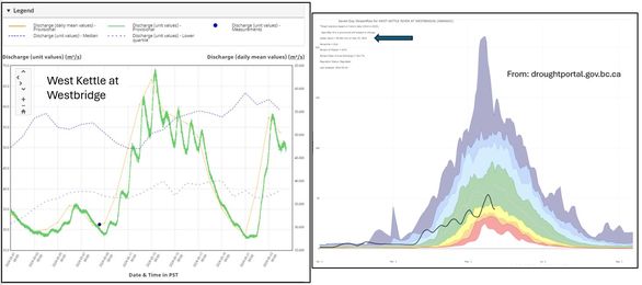
Drought Condition Update – the situation has worsened

Drought Level 3 West Kettle, Upper Kettle River, Granby River watersheds & Okanagan River watersheds. Remaining at Drought Level 2 for Lower and Mid Kettle watersheds. View details at: droughtportal.gov.bc.ca/

Recent weeks have seen a sharp drop in water levels and a rise in water temperatures. The Province has increased the drought level for the Okanagan River watersheds and 3 of the 5 Kettle River sub-watersheds. https://droughtportal.gov.bc.ca/

If you have a BC water license located in a watershed currently at Drought Level 3, you will likely received a letter from the Province recommending you reduce your water use. If you get your water from a service provider (ie. municipality or water users community) they will inform you of any restrictions or requirements that need to be followed.

Conditions – Jul22,2024

This past weekend brought continued high temperatures across the Boundary, making this morning’s sound of rain especially refreshing. Understanding that lightning can accompany rain storms, we are now watching for potential lightning strikes.

Water levels continue to drop rapidly, falling below normal levels for this time of year. Grateful for the cool, wet spring we experienced only a few weeks ago.

Be prepared for continued drying conditions across the Boundary, as minimal rain is forecasted for the upcoming week. Let’s hope this morning’s rain lingers a bit longer.

The following sites help monitor lightning strikes and storm conditions.

Conditions – July19,2024

Boundary Region: Extreme & High Fire Danger Rating

With the continued hot weather, be extra careful driving or spending time in our forests. Our region is drying out very quickly. Know before you go. Get the BC Wildfire App (link below), we are seeing many fire starts close to the Boundary.

Conditions – May24,2024

As we watch the rivers rise with our recent rain, I’m always impressed with those sites that can present our local conditions in an easily accessible format. https://droughtportal.gov.bc.ca/ not only offers drought information but also has links for water levels, how the river levels relate to normal conditions, precipitation and snow condition. This site uses daily averages, and be warned – it is usually a few days behind in uploading the data, but a nice visual for weekly/average conditions.

The images attached look at current water levels from the Water Survey of Canada (wateroffice.ec.gc.ca) for the Granby River and West Kettle River – you can see the rise in water levels from the rain over the past few days, compared to the droughtportal.gov.bc.ca that shows how the daily average compares to previous years. I’ve included an arrow where it tells you the date of the last data upload.

Conditions – May15,2024

As we face low snowpack and hot spring weather, it’s important for us all to prepare for the possibility of a summer drought. Now’s the time to water your plants deeply – watering plants deeply and less often encourages deep root growth, helping them access water stored deeper in the soil during drought. You may want to consider swapping out water-intensive varieties for drought-tolerant options. Luckily, there are plenty of stunning examples of xeriscaping with plants throughout our region. As you’re checking them out, it’s a great time to see which plants are deer-resistant, or at least somewhat deer-resistant! Let’s do our part to conserve water and keep our landscapes thriving.

May be a graphic of body of water and text