Category Archives: Local Conditions

Water Levels: Mar2025

Welcome to the first week of spring – and snow! If you are curious about how our snow and river water levels are doing, read on.

With local temperature expected to reach between 10-15°C in the next few days and more precipitation by Thursday, it’s a good time to look at local conditions.

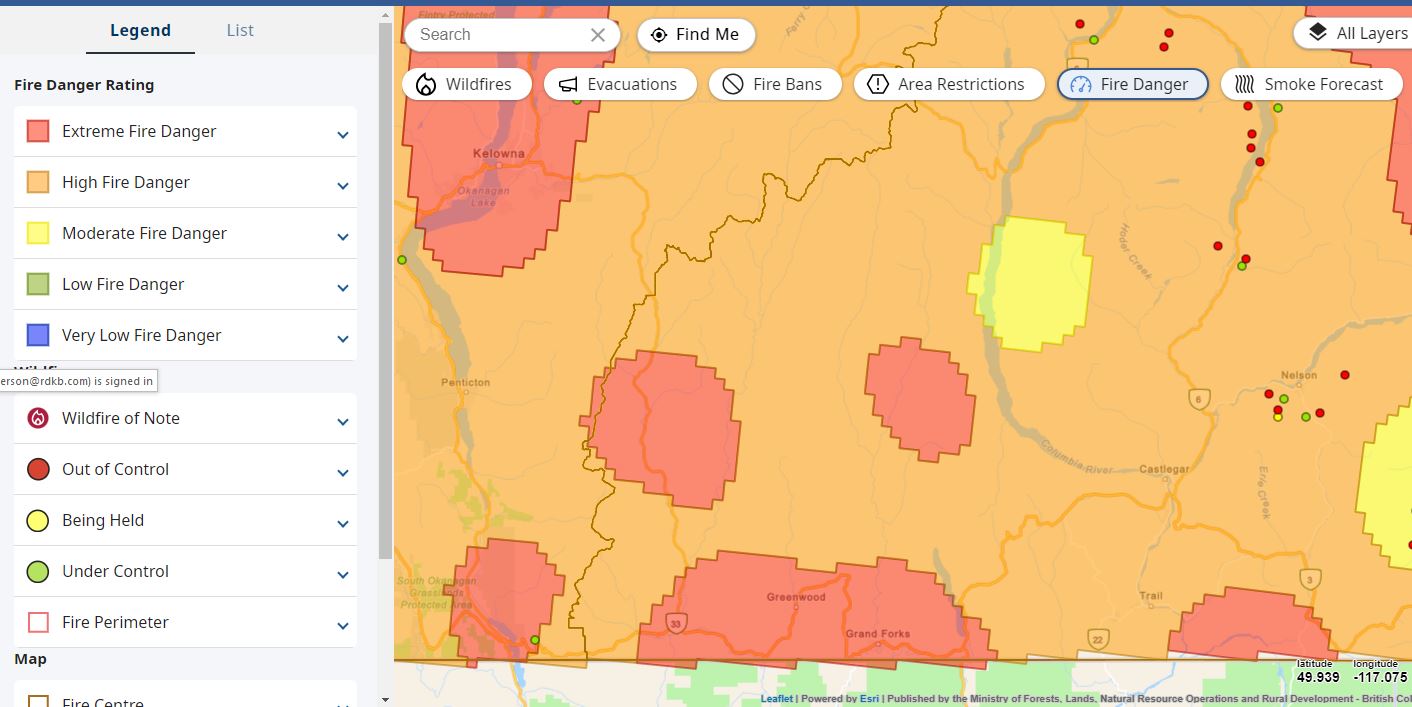
Most of the main river in the Boundary are showing normal water level for this time of year.

Kettle River near Ferry (Midway)
Granby River at Grand Forks

Snow levels, as a percentage of normal, vary across the region and with elevations. South of Grand Forks, at Sentinel Butte, levels are higher than normal. The upper Kettle River watershed, measured at Grano Creek station, is in the normal range. However some of our lower elevations and the stations to the west and north show lower-than-normal for this time of year.

The River Forecast Centre produces a monthly snow report for the province, which shows the March 1st snow level (snow water equivalency) for the Boundary Region at 86% of normal (with 100% being normal). This percentage is based on data from only two BC snow monitoring stations. We hope the April review (posted April 12) can include data from more stations.

Environment Canada anticipates a slightly warmer spring for the Boundary region, with no clear forecast for the spring precipitation levels. As the El Niño/La Niña (ENSO) climate pattern shifts from a La Niña in the winter months to a more neutral state, we expect temperature and precipitation levels closer to normal for the time of year.

Conditions – Aug15,2024

After a very hot July, we have started seeing some relief with slightly cooler temperatures. This has helped both slow down the drop in our river water levels as well as lower the water temperatures –which is very needed for the fish. The Province has maintained the BC Drought code at Level 3 (out of 5) for the Kettle and Okanagan watersheds, asking everyone to reduce water use where possible. RDKB’s drought response plan includes recommendation on actions to take during these drying times.

What does this mean for us in the Boundary? Many of our monitored rivers are showing water levels comparable to 2023, lower than 2022, but higher than in 2021 and 2015. Expectedly, our rivers and streams continue to warm, as water temperature is well correlated to air temp. This is important because rainbow trout can become temperature stressed when water is over 20’C for more than a 24 hr period, shifting to potential lethal if over 25’C, (over a 24hr period). In most cases, when the water depth is sufficient, fish can find cooler refuge at groundwater seeps or in deeper pools. Regarding groundwater, there are 3 local observation wells, showing water levels ranging from normal (Beaverdell) to below normal (Grand Forks). Looking ahead, the fall forecast is for continued warmer and drier compared to normal conditions.

Have you been tracking your groundwater levels over multiple years? The RDKB would be interested in hearing how your readings compare to the nearest observation well. Please email [email protected].

Questions, please contact [email protected]

Conditions – Jul26,2024

Drought Condition Update – the situation has worsened

Drought Level 3 West Kettle, Upper Kettle River, Granby River watersheds & Okanagan River watersheds. Remaining at Drought Level 2 for Lower and Mid Kettle watersheds. View details at: droughtportal.gov.bc.ca/

Recent weeks have seen a sharp drop in water levels and a rise in water temperatures. The Province has increased the drought level for the Okanagan River watersheds and 3 of the 5 Kettle River sub-watersheds. https://droughtportal.gov.bc.ca/

If you have a BC water license located in a watershed currently at Drought Level 3, you will likely received a letter from the Province recommending you reduce your water use. If you get your water from a service provider (ie. municipality or water users community) they will inform you of any restrictions or requirements that need to be followed.

Conditions – Jul22,2024

This past weekend brought continued high temperatures across the Boundary, making this morning’s sound of rain especially refreshing. Understanding that lightning can accompany rain storms, we are now watching for potential lightning strikes.

Water levels continue to drop rapidly, falling below normal levels for this time of year. Grateful for the cool, wet spring we experienced only a few weeks ago.

Be prepared for continued drying conditions across the Boundary, as minimal rain is forecasted for the upcoming week. Let’s hope this morning’s rain lingers a bit longer.

The following sites help monitor lightning strikes and storm conditions.

Conditions – July19,2024

Boundary Region: Extreme & High Fire Danger Rating

With the continued hot weather, be extra careful driving or spending time in our forests. Our region is drying out very quickly. Know before you go. Get the BC Wildfire App (link below), we are seeing many fire starts close to the Boundary.