Category Archives: Science and Learn: Watershed Webinars

Water & Forests

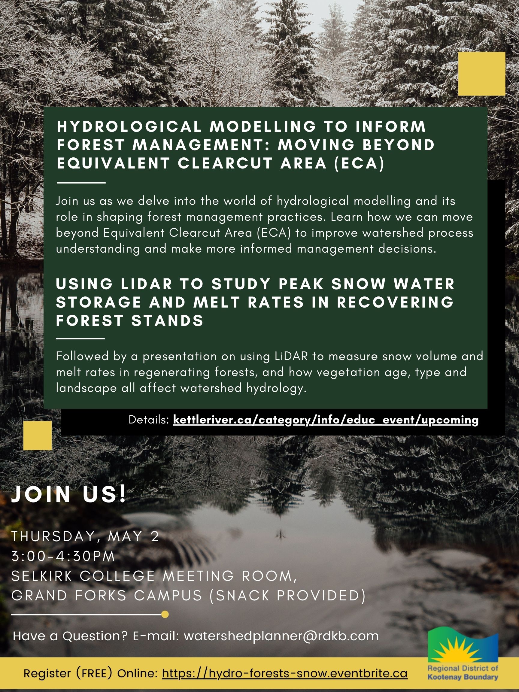
Hydrological Modelling to Inform Forest Management: Moving Beyond Equivalent Clearcut Area (ECA) & Using LiDAR to study peak snow water storage and melt rates in recovering forest stands

  • Selkirk College Grand Forks (meeting room)
  • Thursday, May 2nd. 3:00-4:30pm

Join us as we delve into the world of hydrological modelling and its role in shaping forest management practices. Learn how we can move beyond Equivalent Clearcut Area (ECA) to improve watershed process understanding and make more informed management decision. Followed by a presentation on using LiDAR to measure snow volume and melt rates in regenerating forests, and how vegetation age, type and landscape all affect watershed hydrology.

Both presenters undertake research activities through Selkirk Innovates and are consulting geoscientists with Apex Geoscience Consultants (Nelson, BC). Dr. Kim Green, Co-Founder and senior geoscientist, has worked in the field of watershed science for over 25 years with a focus on hydrology, fluvial geomorphology and geology. Cydne Potter is a geospatial analyst, currently completing her MSc in LiDAR based investigation of hydrological recovery in mountainous regions.

Detailed Description of presentations:
K. Green. Hydrological Modelling to Inform Forest Management: Moving Beyond Equivalent Clearcut Area (ECA). Forest disturbance can alter the hydrologic conditions of a watershed, including the frequency, magnitude, and timing of peak and low flows. Equivalent Clearcut Area (ECA) has been routinely used in watershed assessments to estimate hydrologic change due to forest disturbance. ECA analyses typically rely on broad regional assumptions, qualitative observations, and/or expert judgement, making it difficult to provide accurate measurable estimates of hydrologic change. Process-based hydrological models offer an improved approach as they combine watershed processes, land cover and climate change into the evaluation; providing quantitative estimates of hydrologic change, including at ungauged points of interest. An example using a hydrological model to investigate forest disturbance and future climate change scenarios is demonstrated. Results are contrasted with ECA-based outputs and emphasize that in addition to the amount of forest disturbance, watershed physical characteristics and the location of disturbance within a watershed influence the hydrologic response. This approach provides forest managers with quantitative outputs that support risk-based forest management decisions and presents a substantial improvement over ECA-based methods. Dr. Green will talk about this new approach, focusing on how it’s use in the Kettle River Basin.

C. Potter. Using LiDAR to study peak snow water storage and melt rates in recovering forest stands. Forests affect streamflow magnitude and timing in snow-dominated watersheds by moderating peak annual snow water storage and the timing and rate of snow melt. This two-year study uses handheld LiDAR surveys of below-canopy snowpack to measure the processes by which regenerating forest stands affect watershed hydrology. This talk highlights what we have learned about the roles of vegetation and aspect on the hydrological recovery of the stand and how this might improve our understanding of watershed-scale processes.

Province: Drought

The Province representatives from the Ministry of Agriculture and Ministry of Water, Land and Resource Stewardship will be coming to the Boundary region to host a public meeting on drought. The meeting is focused on water license holders, specifically those in Agriculture, but the meeting is open to anyone that is interested in learning more about how the Province manages, regulates and communicated drought and water licenses.

This is your opportunity to speak with the Provincial staff directly on water licensing and drought impacts in the Boundary Region. Join them in this community learning opportunity at one of the following locations:

  • WEST BOUNDARY/AREA E, GREENWOOD AND MIDWAY
  • Westbridge Community Hall: 2935 Highway 33, Westbridge, BC
  • Wednesday, April 3, 2024, from 5:30pm to 8:00 pm
  • RURAL GRAND FORKS/AREA D, CHRISTINA LAKE/AREAC, GRAND FORKS
  • Grand Forks Curling Club: 7230 21st Street, Grand Forks, B.C
  • Thursday, April 4, 2024, from 9:00am to 11:30am

Questions? Contact the Province at: [email protected]. This is a not a Regional District meeting, but [email protected] can answer some general questions.

They are asking that you register for the meeting on EventBrite to answer some questions and so they know how many snacks to bring: www.eventbrite.com/e/decoding-drought-management-engagement-session-boundary-country-tickets-839401712117?aff=oddtdtcreator

Prescribed Burn: Area E

Map showing the 2023 planned prescribed burn proposed for Area E, 3km NE of Rock Creek.

2023 prescribed burn planned for 3km NE of Rock Creek

Want to learn more about the prescribed burn that happened spring 2022 in the Rock Creek area? Wondering why prescribed burns are happening? What are the benefits? What are the risks?

Check out a recent recording by Lindsey Dewart and James Katasonoff on Ecosystem Restoration and the upcoming prescribed burn. Lindsey and James are two of the Provincial staff involved in this year’s burn, a burn that will be located ~3kms northwest of the Rock Creek fairgrounds (map below).

Ecosystem Restoration and the upcoming Rock Creek prescribed burn
Location of the 2022 prescribed burn (Rock Creek)

The word “fire” can bring a variety of images to mind, depending on a person’s past experiences. In some cases, fires can be beneficial to the landscape. Fire is a natural part of most ecosystems and is required to maintain balance in our forests and grasslands. Introducing more low-intensity fires in the Boundary region under carefully controlled conditions can help restore an ecosystem to help protect nearby communities and benefit watersheds, wildlife populations, and the timber supply.

This spring, the B.C. government is partnering with the Penticton Indian Band, Osoyoos Indian Band, and the West Boundary Community Forest to conduct this 50-hectare prescribed burn northwest of the Rock Creek fairgrounds.

SPEAKERS

Watershed Webinars List

During 2021 and 2022 the RDKB hosted 7 webinars with a focus on the Boundary watersheds. Interested in learning more? Contact the [email protected].

  • What’s Climate Got to Do With It (PCIC)
  • BEC Now and into the future (BC Govt: MacKillop and Mahony)
  • Health and our Watershed (IH- Healthy Communities)
  • Riparian Health and Protection (Coleshill, Stewart and Hesketh)
  • Aquatic Riparian and Fisheries (ONA: Lukey and BC Govt: Hegerat)
  • Wetlands Health and Restoration (Biebighauser)
  • Bentic Invertebrates and CABIN (BC Govt: Raggett and ECCC: Strachan)

Links to each webinar can be found under the main page dropdown menu under “Watershed Webinars”.