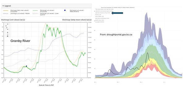
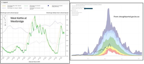
As we watch the rivers rise with our recent rain, I’m always impressed with those sites that can present our local conditions in an easily accessible format. https://droughtportal.gov.bc.ca/ not only offers drought information but also has links for water levels, how the river levels relate to normal conditions, precipitation and snow condition. This site uses daily averages, and be warned – it is usually a few days behind in uploading the data, but a nice visual for weekly/average conditions.
The images attached look at current water levels from the Water Survey of Canada (wateroffice.ec.gc.ca) for the Granby River and West Kettle River – you can see the rise in water levels from the rain over the past few days, compared to the droughtportal.gov.bc.ca that shows how the daily average compares to previous years. I’ve included an arrow where it tells you the date of the last data upload.
As we face low snowpack and hot spring weather, it’s important for us all to prepare for the possibility of a summer drought. Now’s the time to water your plants deeply – watering plants deeply and less often encourages deep root growth, helping them access water stored deeper in the soil during drought. You may want to consider swapping out water-intensive varieties for drought-tolerant options. Luckily, there are plenty of stunning examples of xeriscaping with plants throughout our region. As you’re checking them out, it’s a great time to see which plants are deer-resistant, or at least somewhat deer-resistant! Let’s do our part to conserve water and keep our landscapes thriving.
Feeling the heat lately? With the snow melting and temperatures soaring, our river water levels are rising. Here’s a snapshot of river water levels compared to previous years. While we’re still within the ‘normal range’ (green section), we are on the very lower end of it. Seeing those rivers swell is a good sign, as it replenishes aquifers and nourishes our riparian ecosystems ahead of summer’s dry spell. Let’s stay mindful of our waterways and the balance they bring to our environment. BdryWaterWise
What a difference a few weeks can make – warm to very cold (-30’C in some areas) to above 5’C with rain and rising freezing levels. Still seeing low to very low snow levels throughout our watershed, and rising river levels as they adjust to the recent rain and snowmelt. The Provincial snow monitoring report will be released Feb 8th, with an analysis often including more of the manual snow monitoring stations. Keep hoping for snow, and continue to think of ways that you can reduce water use this summer incase we enter again into a low water period.
Monitoring groundwater and river levels as we left the fall in drought conditions, we are seeing a slight rise in the groundwater levels at the three Provincial monitoring stations, which are all recording average levels: Beaverdell, Midway and Grand Forks. In response to the rain and low elevation snow melt, we are also seeing a rise in river levels throughout are region.
Going forward – what’s coming? Forecasting continues to be a mixture of modelling and human interpretation, so realizing that there is always uncertainty -especially with forecasting more than a few days out. Environment Canada is showing much higher than normal temperatures expected this spring. As we have been seeing all season, there is not a clear message whether we will see low, normal or higher precipitation amts compared to average.
We are still in a strong El Nino period (red), which matches to the high temps we are experiencing. A shift to neutral (grey) and La Nina (blue) is expected for the summer and fall. Normally, La Nina coincides with cooler and wetter conditions, however the summer of 2021 also showed a strong La Nina and the Boundary experienced a drought conditions. Check out the IRI site to see past ENSO forecasting and compare it with what actually happened.
As we are well aware, the Boundary region has less snow than usual for this time of year. According to BC Snow Report, the Boundary snowpack is only 58% of what is a normal snow pack. However, the Province determined this using data from only two sites: Grano Creek (automated) and Monashee Pass (manual), as our other two manual snow stations (Carmi and Big White) are often not measured this early in the season. For information on these snow stations go to the Snow Interactive Map – their snow levels are shown below.
When our snowpack melts in the spring, it gives us the water we need for to recharge our groundwater (aquifers) and rivers. This is needed as nature prepares for the normally drier summer conditions. Now is a great time to consider how best you can prepare to save more water this year, perhaps just by using it more wisely. You might consider using rain barrels to support garden watering, plan for deep watering your trees during the spring allowing for reduced watering in the summer, ensuring there are no leaks in your yard or dripping taps in your house.
We have several more months to accumulate snow, so keep up the snow dances and let’s hope this recent cold snap is joined by more of that fluffy white stuff.
Check out the following sites for more information:
The BC Government publishes a monthly Province Wide Snow Report with this first one out in January. Our lower snow pack was anticipated as BC is experiencing a strong El Nino presence, anticipated to be returning to a more neutral state this spring. With a more neutral influence, we expect to see temperatures also returning to more normal conditions.
The 3 month forecast for both Temperature and Precipitation shows that we should continue to expect higher than normal temperatures for the remaining winter months, but no clear information on what to expect for snow levels.