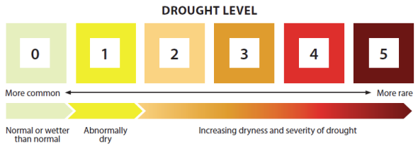
The Province has changed how it calculates the Provincial Drought Levels , which is different than what they have done in the past 10 years. Check out the document below for a quick summary explaining the changes.
You can find the drought Levels at the BC Drought Portal: https://droughtportal.gov.bc.ca/ The BC Drought and Water Scarcity Response Plan explains the new system: https://www2.gov.bc.ca/assets/gov/environment/air-land-water/water/drought info/drought_response_plan_final.pdf
Key things to know:
* 2025 Provincial drought levels can’t be compared to past years. * 2025 levels are based on observed conditions at a specific date and do not include forecasts or water scarcity impacts like before. * Social or ecosystem impacts are not included in the new system.
Communication: Unlike past years, the Province will not send letters to water license holders to let them know about drought level changes or ask for voluntary water use reductions. Communities need to check this information themselves. Provincial drought communication will mostly be provided through the BC Drought Portal.
It’s that time of year again—the snowpack is melting across the watershed, sending pulses of water down our rivers. This annual event, known as the spring freshet, is one of the key forces shaping our messy rivers.
Flooding is a familiar experience for many in the Boundary, and for some, freshet season brings heightened anxiety. But while high water can be destructive in human terms, it’s also a vital ecological process. The spring freshet transports sediment—important for building floodplains and gravel beds—and moves coarse woody debris, which adds structure and complexity to aquatic habitats. These materials help rivers shift and meander, creating new side channels, wetlands, and microhabitats that support diverse plant and animal communities. In short, freshet is the river’s way of renewing itself.
Perhaps most critically, spring freshet sets the stage for the summer. As water spills out of riverbanks and slows in the floodplain, it spreads across wetlands and backchannels. Some of that water seeps into the ground, recharging the aquifers that supply us with cool, clean water during the dry months. The ground itself acts like a natural filter, cleaning the water as it moves through layers of soil and rock. This recharge is essential—not just for drinking water and irrigation but maintaining baseflows in rivers and streams high enough to support fish, amphibians, and other aquatic life through the hottest parts of the year.
When spring freshet is healthy, the whole system benefits: wetlands remain saturated, groundwater stays available, forests are less stressed, and salmonids and amphibians find refuge in cool, connected waters.
But we also know that climate change is making freshets less predictable. Warmer winters, rain-on-snow events, and altered snowpacks can all affect how—and when—water moves through the system. That’s why building resilience at the community level is so important.
Resilience can look like many things: protecting and restoring wetlands that act like sponges during high flows; reconnecting rivers to their floodplains; planting riparian vegetation that slows erosion and shades the water; and designing infrastructure that works with the river instead of against it. It also means making space for the river to be messy—to rise, fall, spread, and shift.
Freshet is not the enemy; it’s a pulse of life. And when we understand it, respect it, and make room for it, our communities and ecosystems are better off—not just in spring, but all year long.
One could argue that the Kettle and Granby Rivers are among the most spectacular waterways in the southern interior of British Columbia: still untamed, wild, full of native fish, and surrounded by a rich diversity of species—many of them at risk.
It’s that time of year when Rainbow Trout begin to spawn, which is why many streams in the Boundary region are closed to fishing in the spring, from April 1st to June 30th including the Granby River.
Some of the “messiness” in river ecology and restoration comes in the form of coarse woody debris. These fallen trees and branches from the riparian zone are essential in shaping habitat: they create deep pools, slow flows, and form hiding places. These deep pools provide much-needed refuge for Rainbow Trout during the heat of summer—this is also the reason behind the summer closure on the Kettle River, where such pools are scarce.
Coarse woody debris also serves as a landing strip for adult insects laying eggs in the river, and for emerging aquatic larvae. It’s another reason fish gravitate toward these structures—they’re a buffet of insect life and offer shelter from overhead predators like osprey and bald eagles.
The creation of side channels—shaped by the rivers’ natural meandering and the placement of large woody debris—is especially important during high water. These areas offer trout a break from intense flows and are prime locations for building redds—the nests where they lay their eggs. Ideal spawning grounds feature a mix of gravel sizes, good water flow, and little fine sediment, allowing for oxygen-rich conditions crucial to developing alevins, or larval trout.
As the freshet builds and spring rains swell our rivers, the messy beauty of these wild systems comes into its own—offering refuge, nourishment, and a place for the next generation of trout to begin.
Let’s protect that mess. Whether it’s respecting seasonal closures (ensure to check local fishing regulations), supporting restoration projects, or simply spreading the word about the vital role of side channels and woody debris, every action matters. The more we understand the needs of our rivers—and the life they sustain—the better we can stand up for them. After all, wild rivers need wild hearts to keep them flowing free.
Tiger Salamander rescued from below a cattle guard on Gilpin FSR by Biologist, Jenny Coleshill. Never touch amphibians as the oils and possible contaminants on our hands may be harmful.
Learn more and come out to Boothman’s Oxbow Provincial Park on April 10 to learn about our local amphibians.
About this event
Welcome to Amphibian Wonder!
Come join us for an evening of exploration and discovery at Boothman’s Oxbow Provincial Park, it will be ribbiting!
Date: Thu Apr 10 2025
Time: 6:00 PM
Location: Boothman’s Oxbow Provincial Park
Step into the fascinating world of amphibians and discover the incredible creatures that call this park home! Join us for a fun and educational adventure where you’ll learn about their unique adaptations, habitats, and importance to the ecosystem. Bring your friends and family for an unforgettable experience in nature!
Come on out and experience flyfishing and learn about riparian areas through the lens of fish and insects! Location will be announced closer to the date.
About this event
Welcome to the World of Flyfishing!
Feel comfortable among other woman for an afternoon of flyfishing.
Dates: July 11th and September 12th
Time: 6:00 PM
Location: To be annouced closer to the date. Sign up to ensure you receive the latest updates.
The best way to learn how to fly fish is to immerse yourself in the world of riparian areas—the special places where water meets land and magic happens! These vibrant ecosystems are where terrestrial and aquatic wildlife thrive, and where you’ll discover the true rhythm of the river. Join us for a fun and educational day of fly fishing, designed especially for women who want to connect with nature, learn new skills, and enjoy the water together!
Learn about the critical habitat for the Lewis’s Woodpecker and the many species at risk that rely upon our riparian areas!
About this event
Welcome to the world of birds!
Explore one of the most cherished havens for birds!
Dates: JUNE 27th in Grand Forks: 5:00pm AND JULY 17th in Midway: 5:00pm
Time: 6:00 PM
Location: To be annouced closer to the date. Sign up to ensure you receive the latest updates.
More dates will be added if needed.
Join a local biologist to explore the favorite habitat of the Lewis’s Woodpecker and discover the incredible birdlife of the Boundary! As we wander through the riparian habitat, we’ll marvel at the beauty of the cottonwood nest trees and, if we’re lucky, hear the calls of hungry chicks awaiting their next meal. Bring your own birding stories to share and immerse yourself in the beauty of this vibrant ecosystem!
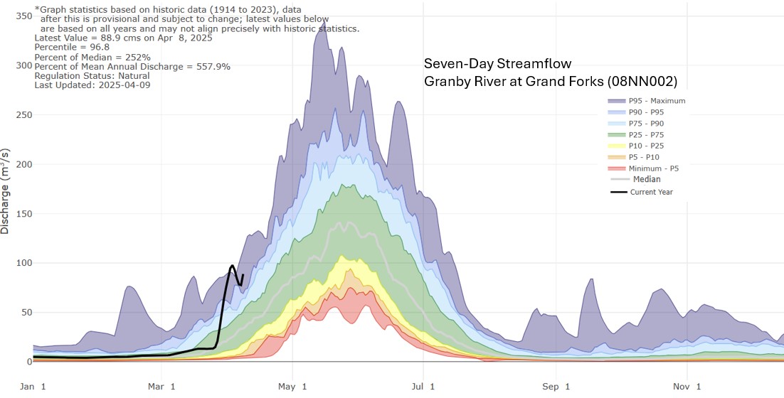
Spring has sprung, and water levels are starting to rise as the snow level drops. Read on to see how our current water levels compare to previous years. Spoiler Alert: we are experiencing water levels higher than normal for this time of year, with some reaching levels typically seen during a normal spring melt (freshet). Snow levels are decreasing quickly at some stations, bringing the high snow level station to a more average level. The Provincial snow report for April2025 describes the snow levels in the Boundary Region as normal for this time of year.
With local temperature remaining warm, reaching highs between 10-15°C over the next week and minimal precipitation expected, it’s a good time to access local conditions.
Many rivers and streams in the Boundary region experienced a sudden rise due to recent warm weather and rain. Below is the hydrograph for the Granby and Kettle River (south of Midway).
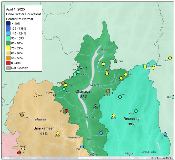
Province produces a monthly snow report (April 2025), indicating snow levels in the Boundary Region are overall normal for this time of year, an assessment based on 4 monitoring stations (Figure 3 and 5). As we know, snow levels vary across the region and with elevations changes. South of Grand Forks at Sentinel Butte, it’s snow levels are dropping to more typical levels; along with the Grano monitoring station, located in the upper Kettle River watershed, also within a normal range (Figure 4). With the lower elevations stations (Carmi and Monashee Pass) are slightly lower than normal for this time of year.
Figure 3. Stations included in the Provincial Snow Monitoring Report for April 1, 2025. Snow ReportFigure 4. Sentinel Butte (south of Grand Forks) and Grano Creek (Upper Kettle River watershed) stationsFigure 5. Dated: April 1, 2025. Snow Survey and Water Supply Bulletin – April 1st, 2025Figure 6. Compared to the rest of the Province, the Boundary region has relatively higher snow level
Environment Canada forecasts a warmer than normal spring for the Boundary region, with the potential for drier conditions (Figure 7). Temperature Probabilistic Forecasts
As we transition into the spring melt period (freshet), here are some useful resources to monitor: