Category Archives: Local Conditions

Conditions – Jul11

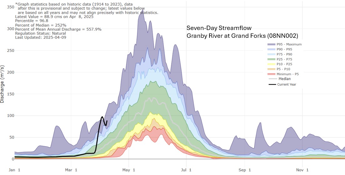
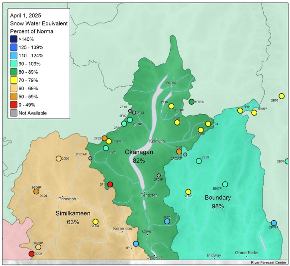
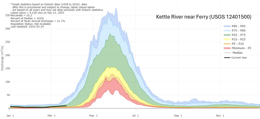
The Province has elevated the drought level of the Kettle and Okanagan watersheds to Level 3, highlighting the ongoing dry conditions affecting both areas. Rainfall during the past week has been minimal, with most stations recording only 2mm or less; however, the southern half has marginally benefited from the accumulated 20-35mm of rain over the last 30 days. Despite this, Agriculture Canada reports continue to show very dry soil moisture levels throughout the Boundary. Are you experiencing similar conditions in your area? Have you noticed the low water levels in local streams, even the Kettle River at Laurier is getting close to it’s minimum recorded level for this time of year (image below).

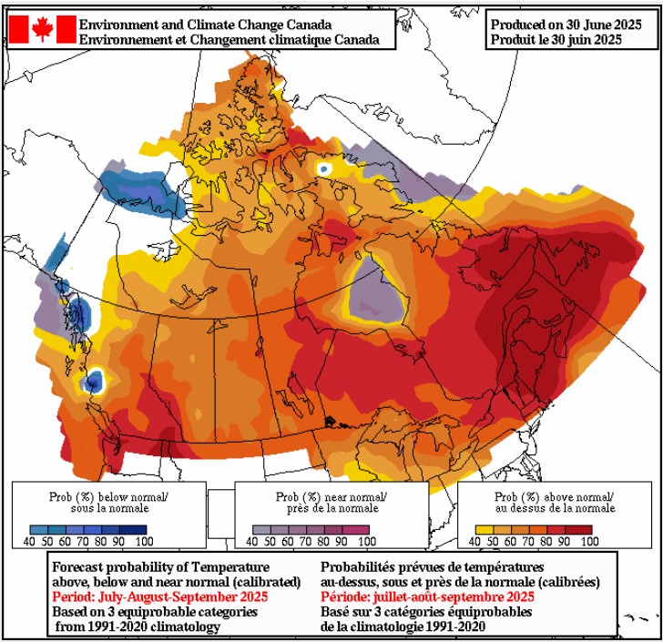
It’s important to note that Provincial drought levels no longer reflect weather forecasts or impacts. Local forecasts (images below), suggest continued dry conditions with minimal rainfall expected over the coming two weeks (SpotWx) and for the next three months (EnviroCanada).

We urge everyone to remain WaterWise and FireSmart:
• Regularly check and repair any water leaks, such as a leaking toilet, irrigation line, etc
• Water your gardens during cooler parts of the day.
• Use mulch to retain soil moisture and reduce water needs.

💧 What are you doing to help ensure water remains available for all species in these watersheds. 🌿 Share your water-saving tips and inspire others!💧

Provincial Drought Levels: https://droughtportal.gov.bc.ca/
For more information on the change to the Provincial drought level rating system, please see: https://kettleriver.ca/2025/07/drought-level-reframed/

NOTE: Local Conditions updates will resume at this site in August. Check out the Provincial Drought Portal https://droughtportal.gov.bc.ca/ for information on the Kettle and Okanagan watersheds.

Drought Portal: https://droughtportal.gov.bc.ca/

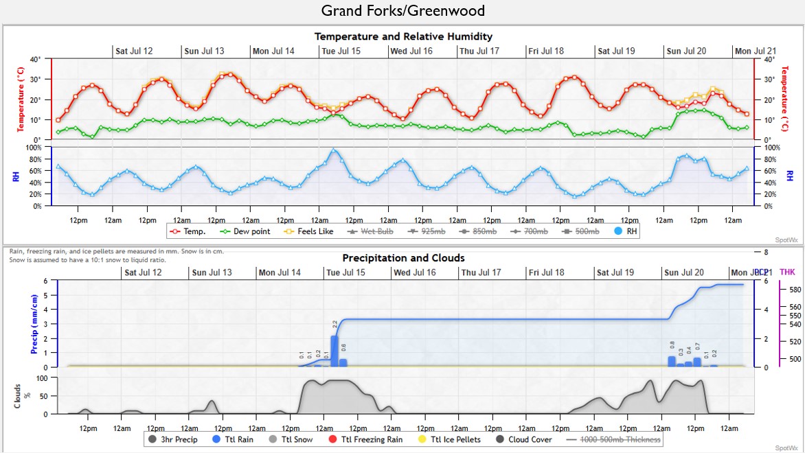
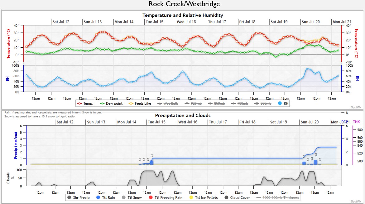
Forecast for the next 10 days: Grand Forks/Greenwood & Rock Creek/Westbridge

Conditions – Jul4, 2025

🌧️ Last week’s rain made our river levels rise a bit, but they’re still lower than usual for this time of year.🏞️ Have you noticed the levels dropping quickly? The groundwater levels, those directly affected by the Kettle River (unconfined), are doing okay in Midway and Beaverdell; however, they’ve dropping a bit more in the Grand Forks area. Are you noticing this at your wells? 🌡️ With the hot weather continuing and only a bit of rain forecasted, our river levels will likely keep falling across the Boundary Region while the fire danger rating increase. 🌳

Let’s keep being WaterWise and FireSmart.🏞️ Every effort counts, not just for today but for the future too! 💧

📊 The hydrographs below show river water and groundwater levels for the Granby River, Kettle River, and West Kettle River. The second graph in the image highlights the groundwater well level that is most closely connected to these rivers. 🏞️💧

Drought Level Reframed

The Province has changed how it calculates the Provincial Drought Levels , which is different than what they have done in the past 10 years. Check out the document below for a quick summary explaining the changes.

You can find the drought Levels at the BC Drought Portal: https://droughtportal.gov.bc.ca/
The BC Drought and Water Scarcity Response Plan explains the new system: https://www2.gov.bc.ca/assets/gov/environment/air-land-water/water/drought info/drought_response_plan_final.pdf

Key things to know:

* 2025 Provincial drought levels can’t be compared to past years.
* 2025 levels are based on observed conditions at a specific date and do not include forecasts or water scarcity impacts like before.
* Social or ecosystem impacts are not included in the new system.

Communication: Unlike past years, the Province will not send letters to water license holders to let them know about drought level changes or ask for voluntary water use reductions. Communities need to check this information themselves. Provincial drought communication will mostly be provided through the BC Drought Portal.

April 9, 2025

Spring has sprung, and water levels are starting to rise as the snow level drops. Read on to see how our current water levels compare to previous years. Spoiler Alert: we are experiencing water levels higher than normal for this time of year, with some reaching levels typically seen during a normal spring melt (freshet). Snow levels are decreasing quickly at some stations, bringing the high snow level station to a more average level. The Provincial snow report for April2025 describes the snow levels in the Boundary Region as normal for this time of year.

With local temperature remaining warm, reaching highs between 10-15°C over the next week and minimal precipitation expected, it’s a good time to access local conditions.

Many rivers and streams in the Boundary region experienced a sudden rise due to recent warm weather and rain.  Below is the hydrograph for the Granby and Kettle River (south of Midway).

Figure 1. Kettle River near Ferry (Midway). Graph from BC Drought Information Portal (7Day Streamflow Map)
Figure 2. Granby River at Grand Forks. Graph from BC Drought Information Portal (7Day Streamflow Map)

Province produces a monthly snow report (April 2025), indicating snow levels in the Boundary Region are overall normal for this time of year, an assessment based on 4 monitoring stations (Figure 3 and 5). As we know, snow levels vary across the region and with elevations changes. South of Grand Forks at Sentinel Butte, it’s snow levels are dropping to more typical levels; along with the Grano monitoring station, located in the upper Kettle River watershed, also within a normal range (Figure 4). With the lower elevations stations (Carmi and Monashee Pass) are slightly lower than normal for this time of year.

Figure 3. Stations included in the Provincial Snow Monitoring Report for April 1, 2025.  Snow Report
Figure 4. Sentinel Butte (south of Grand Forks) and Grano Creek (Upper Kettle River watershed) stations
Figure 5. Dated: April 1, 2025. Snow Survey and Water Supply Bulletin – April 1st, 2025
Figure 6. Compared to the rest of the Province, the Boundary region has relatively higher snow level

Environment Canada forecasts a warmer than normal spring for the Boundary region, with the potential for drier conditions (Figure 7). Temperature Probabilistic Forecasts

As we transition into the spring melt period (freshet), here are some useful resources to monitor:

  1. RDKB Emergency Operations: The Boundary Region Dashboard is now being updated, offering an overview of freshet conditions across the region. emergency.rdkb.com/
  2. River Forecast Centre (CLEVER) provides water level forecasts for 10 rivers throughout the Boundary Region.

Water Levels: Mar2025

Welcome to the first week of spring – and snow! If you are curious about how our snow and river water levels are doing, read on.

With local temperature expected to reach between 10-15°C in the next few days and more precipitation by Thursday, it’s a good time to look at local conditions.

Most of the main river in the Boundary are showing normal water level for this time of year.

Kettle River near Ferry (Midway)
Granby River at Grand Forks

Snow levels, as a percentage of normal, vary across the region and with elevations. South of Grand Forks, at Sentinel Butte, levels are higher than normal. The upper Kettle River watershed, measured at Grano Creek station, is in the normal range. However some of our lower elevations and the stations to the west and north show lower-than-normal for this time of year.

The River Forecast Centre produces a monthly snow report for the province, which shows the March 1st snow level (snow water equivalency) for the Boundary Region at 86% of normal (with 100% being normal). This percentage is based on data from only two BC snow monitoring stations. We hope the April review (posted April 12) can include data from more stations.

Environment Canada anticipates a slightly warmer spring for the Boundary region, with no clear forecast for the spring precipitation levels. As the El Niño/La Niña (ENSO) climate pattern shifts from a La Niña in the winter months to a more neutral state, we expect temperature and precipitation levels closer to normal for the time of year.