Tag Archives: riparian

Frequently Asked Questions:

What is a riparian area?

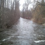
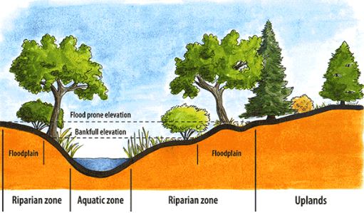
A riparian area is the area of land adjacent to a body of water (ie: streams, creeks, lakes, wetlands, ponds, etc) that plays a crucial role in maintaining water quality, preventing erosion, and providing habitat. It forms a corridor between the land and a body of water, whether the water is flowing or standing. The overall area is made up of three zones: the aquatic zone, the riparian zone, and the upland zone. A healthy riparian area contains diverse plant species and both aquatic and terrestrial wildlife.  

The aquatic zone is the water body itself, including the stream bed, banks, and any submerged vegetation. Key features of the aquatic zone include:
– Providing habitat for fish, invertebrates, amphibians, and reptiles
– Supporting aquatic plants like algae, aquatic grasses, and rooted plants
– Playing a vital role in water filtration and nutrient cycling

The riparian zone is the transitional area between the aquatic zone and the upland zone. Key features of the riparian zone include:
– Inclusion of wetlands, marshes, and swamps
– Providing habitat for a variety of wildlife (birds, mammals, and insects)
– Characterized by moisture-loving plants like willows, alders, and cottonwoods
– Helps with bank stability and the prevention of erosion

The upland zone is the higher and drier area that borders the riparian zone. Key features of the upland zone include:
– Can include forests, grasslands, and/or agricultural fields
– Less directly influenced by the water body, but still plays an important role in the overall ecosystem
– Can serve as a buffer that protects the riparian zone from disturbances

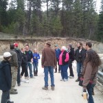
Why does this project exist?

Along waterways the loss of land from erosion, increased sedimentation and loss of habitat is a growing concern in the Boundary. As extreme weather events become the norm, this project aims to identify riparian areas throughout the Boundary that are at risk of future degradation. 

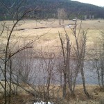
What causes a riparian area to be ‘at risk’?

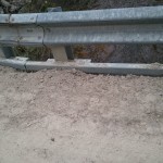
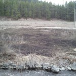
In general, an unhealthy riparian area is one with poor soil quality, little-to-no plant life, and/or no diversity in the plants and wildlife present:
– Poor soil composition in the riparian zone has a higher potential for erosion during high moisture events.
– A lack of both aquatic and terrestrial plant species is an indicator of an unhealthy riparian area. Trees, shrubs, and some grasses use their roots, water uptake ability, and mass to help stabilize the banks and waterways. They play a crucial role in preventing erosion

Why does it matter if a riparian area is at risk?

When a riparian area is lacking these fundamental building blocks (healthy soils, diverse vegetation and wildlife, etc), it holds the potential to cause downstream damage. High water events, such as heavy rain fall or flooding, can move large amounts of sediment downstream. The sediment is deposited in slower-moving areas like floodplains and river bends, forming gravel bars or islands. These formations can alter the flow of water, potentially causing erosion or flooding. Additionally, these new routes can reduce the water depth, leading to increased water temperatures during the summer months. This warmer water can harm fish, invertebrates, and amphibians. The increase of sediment in the water can water quality, hindering vegetative growth and reducing oxygen levels for fish. While a certain amount of sediment movement is necessary for a healthy ecosystem, excessive amounts can have detrimental effects.

What else?

Have you got a question that we missed? Feel free to reach out to [email protected] with your questions!

Kettle River Q&A: What did we learn about issues on the water’s edge?

On April 15, nearly 40 residents of the Boundary came together in Grand Forks to learn and share ideas about issues at the water’s edge – floodplains, riparian areas, and wetlands.

The Regional District of Kootenay Boundary held the meeting to gather input on key issues in the Kettle River Watershed Management Plan before the plan is finalized.

I gave a presentation (pdf)with photos showing the good, the bad and the ugly. We also learned from Jenny Coleshill of the Granby Wilderness Society about the importance of riparian areas and her current work to assess how people are impacting them.

Participant Donna Seminoff asked a question that bears repeating: “Can you break it down for everyone – what happens when people cut trees and shrubs on the shoreline?”

The long answer depends on the site, the soils, and the stream or lake setting. But here’s the short of it:

Trees, shrubs and native plants have large root systems that buffer moving water during floods. When we remove them and replace them with non-native grass, which has much shallower roots, high waters can easily undermine banks and cause them to slump, and water running over the surface can carve into the banks. The added sand, gravel and stones in turn provide even more material and energy to the river, leading it to spread out further downstream.

Mown grass can't hold the bank together during heavy rains
Mown grass can’t hold the bank together during heavy rains

Participants worked in groups on four main topics: limiting risks from flooding and erosion; improving riparian areas near development; controlling impacts of resource roads on stream health; and encouraging agricultural protection and conservation of streams and wetlands.

Mark Andison, RDKB General Manager of Operations, noted that the public raised a broad range of potential solutions, “everything from re-establishing the Granby Dam, to dredging gravel, to giving out trees and shrubs for shoreline property owners.”

Some of the other suggestions included implementing ecosystem-based stewardship in resource management areas, building skills and providing a ‘toolkit’ for grassroots monitoring and stewardship, developing incentives and land-use control rules for developing near water, and regulation and pricing that makes resource users and polluters pay more of the costs of regulation and impacts on other users.

I spoke with Doug Fossen from the Kettle River Stockmen’s Association after the event for his perspective. Fossen said that much work is being done on improving both private lands and range management areas, and that funding is available for many projects – “working with the Environmental Farm Plan you can access funding for off-site watering, riparian fencing, irrigation improvements or other projects.”

We are following up on the meeting with a discussion paper that works through the issues and solutions and outlines concrete, practical actions to reduce risks and improve environmental conditions.

Thank you to the RDKB for hosting the event and all of the participants for their involvement.

– Graham Watt is the coordinator of the Kettle River Watershed Management Plan for the RDKB, and is working with a Stakeholder Advisory Group from across the region to develop the plan. Email [email protected]

Tour of Boundary Creek Riparian Conditions

Getting out of the office and boardroom to see real-world conditions is a highlight for watershed planners and stakeholders. Members of the Stakeholder Advisory Group, Riparian Working Group, and the Boundary Central Secondary Sustainable Resources 12 students and teacher Lisa Baia looked over riparian conditions at four sites on Boundary Creek Road, Greenwood, and Boundary Creek Provincial Park. Thanks to Fred Marshall for leading us through the tour and to Lisa for arranging the bus and bringing the keen students. Here’s some of the highlights.

Kettle River Q&A – Are Resource Roads a Problem in the Boundary?

The last thing you want to come across when traveling out into the backcountry this summer is a road wash-out, blown culvert or failing bridge.

But a recent report from the B.C. Forest Practices Board reveals an increasing number of concerns over poor road and bridge construction and maintenance in audits of forestry operations across the province. In particular, key issues included less overall maintenance work and insufficient culverts and drainage structures.  Continue reading Kettle River Q&A – Are Resource Roads a Problem in the Boundary?